‘Walk Around Wylam’ was written by local historian Philip R. B. Brooks. First published by Wylam Parish Council in 1982, it was revised and updated for the previous website in 2016. Philip served as a member of Wylam Parish Council for 40 years from 1973 to 2013. The text has been copied across from the old web site with some small changes. The map is a new version and is under construction (but the route is accurate).
This brief guide describes many of the features of interest which can be seen in this attractive and historic village, nicknamed locally as “Where Railways were Born”. Following the itinerary described, the walk is about 5km (3 miles) and should take most people about 2½ hours, but the route can be easily varied by referring to the map below (click on it for a larger on-screen version). There are short stretches of uneven ground and a few steps.
This page is still in preparation, especially the map. The map is based on OpenStreetMap®. It is open data, licensed under the Open Data Commons Open Database License (ODbL) by the OpenStreetMap Foundation (OSMF). Many buildings mentioned in the text have index numbers. These will be inserted into the map very shortly (as at 18 April 24).
Itinerary
Start at the Parish Church (1), the only one in Northumberland dedicated to St. Oswin. Oswin was King of Deira (the southern half of Northumbria) from 644 until 651 and his kingdom extended from the Humber to the Tees, with York as the capital. His cousin Oswy ruled over the adjoining northern part of Northumbria, known as Bernicia. Following several disputes between them, their opposing armies met for battle near Catterick in 651 and Oswin, whose men were outnumbered, fled shortly afterwards. He was betrayed to Oswy and slain at Gilling near Richmond. He was later buried in the Priory at Tynemouth.

The foundation stone of the Parish Church was laid by Mrs. Richard Clayton of Wylam Hall on 1st January 1885, in the presence of the donor, George Hedley and his brother William, the youngest sons of William and Frances Hedley. The two brothers had been born in the village shortly after their father had taken up his job as the colliery viewer in 1805 and were small children at the time of the development of the early locomotives in Wylam between 1812 – 15, in which their father played a major part. Although George Hedley died in July 1886 before the church had been completed, his brother gave £10,000 to endow the living and build the parsonage. The total cost of building the church was £7,061.
Wylam formed part of the ecclesiastical parish of Ovingham until 1902 when, with Horsley, it became a separate parish. Although there was no parish church until 1886, the Wesleyans had had a chapel in the village at least half a century earlier and part of the present Methodist Chapel (2) in Chapel Lane dates from 1834. During the 18th century, non-conformists in the village probably worshipped at a meeting place at nearby Horsley, which was visited by John Wesley several times during his trips to Northumberland.
From the early 12th century until the dissolution of the monasteries by King Henry VIII, the village belonged to the Priors of Tynemouth, and Wylam Hall (3) (private grounds) incorporates part of the ‘Sporting House’ built for the monks by Prior Whethamstead in 1405. Little of the original mediaeval work remains in the Hall, which has been substantially altered since that time.
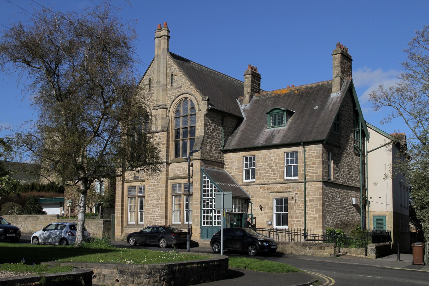
Turn left through the lychgate outside the church, passing Wylam Institute (2a) (built by public subscription in 1895) with the attractive bungalows Blackett Cottages facing it across the road. The cottage in which the original Reading Room and Institution was housed stood where the bus shelter now stands on the opposite corner.
At the road junction, a left turn would bring you into the centre of the village with shops and refreshment establishments, but there is little of special historic interest there, except the mounting block outside the Black Bull Inn (4), so instead follow the road to the right and stop at the corner of Woodcroft Road.
The house facing the end of Woodcroft Road has been known as Brewery House (5). The outbuildings of the former brewery stood at the back of this house until replaced by flats in recent years. The brewery itself closed in the 1870’s, not long after the main colliery and the ironworks ceased production, when the demand for a local brew must have dropped! Brewery House, with its neighbour, Willow House (at one time the colliery manager’s house) are both late 18th century buildings and with West House, form an attractive group fronting the Ovingham Road. This pleasant road which runs along the riverside linking Wylam and Ovingham was originally constructed in the mid-18th century by John Blackett of Wylam Hall.
Turning down Woodcroft Road, the former Colliery School and Schoolhouse (6) stand on the left. The school is a fine but somewhat austere stone building completed in 1854 (note the date stone on the bell-tower). It continued to be used until the new County Council school (now itself replaced) was built on Falcon Terrace in 1910. Its construction was largely promoted by J.F.B. Blackett, the local squire, who had also been responsible for establishing the Reading Room and Institution in the village in 1850. Elected an MP for Newcastle in 1852, Blackett died four years later at the early age of 35. During his short Parliamentary career he made a considerable impact and was undoubtedly one of the most able members of the local Blackett family who were Squires of Wylam for a period of nearly 300 years from about 1679 to 1971. The older building to the left of the 1854 school was used as an earlier school and later as the master’s house, but is now a private residence. The school itself is now a mission hall.
On the opposite corner stood the White House (7), home of William Hedley and his family between 1805 and 1827. A plaque was erected on the present house in 1979 to commemorate the 200th anniversary of Hedley’s birth and his important contribution to railway history.
Continue down Woodcroft Road, but instead of following the road to the left, cross to the corner and walk down the narrow path (behind the Lime tree) which leads onto the old railway track (8). This formed part of the 61/2 mile long Scotswood-Newburn-Wylam railway which was begun in 1872 and finished four years later at a total cost of just over £100,000. Never a financial success, it was taken over by the North Eastern Railway Company in 1883. The line eventually closed in 1968 and was subsequently acquired by the County Council to create a walking, cycling and horse-riding route. It now forms part of the Tyne Riverside Country Park, which extends westwards to Low Prudhoe and eastwards across the county boundary to Newburn.

Turn right and walk westwards along the track towards Hagg Bank or Points Bridge (9) which spans the river. Completed in 1876 to designs by W. G. Laws (subsequently City Engineer of Newcastle) this wrought iron bridge is reputedly the first arch-rib design bridge built to support a suspended railway track. It has similarities to the bridges at Sydney Harbour and over the Tyne at Newcastle – both of more recent and slightly different designs. It cost £16,000 to build. There are pleasant views up-river from this bridge.
The length of river bank east of Hagg Bank is known as Wylam Scars (10) and it was here that work on the Newcastle-Carlisle railway began in 1831. The scene was delightfully illustrated by J.W. Carmichael in one of his famous views of this railway. This was the first east-west coast-to-coast line to be built in Britain and the first section, between Blaydon and Hexham, opened on 9 March 1835.
Now return along the disused railway track to the point at which you joined it earlier and then follow the narrow path to the right, towards the tree-covered mound alongside the river. This was the spoil heap of the former Wylam Colliery (Haugh Pit) (12). The colliery winding engine stood on the site of the small group of allotments, where a sub-station and electricity poles are now grouped. Thomas Hair, another famous local artist, painted a fine series of views of the collieries in the north east, including one depicting the Haugh Pit in 1839, showing the winding engine and pit head, and a colliery locomotive.
The Wylam waggonway was built in the mid-18th century and was one of the earliest in the north of England. It ran from this point eastwards alongside the Tyne for five miles linking the colliery to loading staithes on the river at Lemington, where the coal was loaded into keels (barges) for transporting to ships waiting in the mouth of the Tyne.
The colliery workings extended under the river and suffered badly from flooding and these problems, together with the high costs of transporting coal on the waggonway resulted in this colliery operating at a loss for several years before it was eventually closed late in 1868. Subsequently, the waggonway fell into disuse and was in poor condition when construction of the Scotswood-Newburn-Wylam railway, which followed the waggonway route for much of its length, was begun four years later.
From the old pit heap, follow the path eastwards along the top of the playing field, and stop just before the exit (public toilets nearby). Timothy Hackworth, the famous railway engineer, who was at one time blacksmith at Wylam Colliery, was born in a cottage which stood near the entrance to the playing field, and a plaque on the present house, Wormald House, commemorates this, Hackworth’s birthplace (13).
Leaving the playing field, turn right, stopping just before you reach Wylam Mill (14).
Early in the 19th century, the colliery pumping engine (used for extracting water from the mine workings) might have been seen on the right, together with the colliery workshops. These have all disappeared, apart from an old single-storey stone building with a pantiled roof which has been restored but was in use as the Blacksmith’s Shop (15) until the 1930’s. It has been suggested that it was in this building that the first Wylam colliery locomotives were built by William Hedley, Timothy Hackworth and Jonathan Forster, in 1813-1815. There is there is no conclusive proof if this and early maps of the area seem to show that the present building is not as old as this, although some repairs to colliery equipment may have been undertaken here.

The two-storey redbrick Victorian building set back from the road frontage, was built as the mill stables and is now the Coop store. Wylam Mill itself was originally driven by water from the Oakwood Burn but in 1876 it was modernised and converted into a steam mill. It became a thriving concern by the turn of the century (the size of nearby ‘River House’ which was the miller’s house certainly suggests prosperity) grinding flour and feedstuffs for many local farmers. However, on August 9th 1931, a dramatic fire completely destroyed the premises, necessitating the demolition of the mill buildings, including the chimney which had been a prominent local landmark. The rebuilt mill has been converted into dwellings in modern times.
The side-road, Tyne View, to the left of the mill leads down to the Old Ford (16), which, apart from a small ferry, had been the only means of crossing the river before the opening of the bridge. Even after the bridge was built, the ford continued to be well-used by drovers who wanted to avoid having to pay the bridge tolls. Newburn Bridge (17) was built in 1836 to link the ironworks and the colliery to the newly opened Newcastle-Carlisle railway on the south side of the river. John Blackmore, engineer to the railway company, designed the bridge and performed the opening ceremony on 25 April 1836. It originally had a railway track on it to take coal to the railway on the south bank (see below).
The original toll-house stood at the southern end of the bridge at the entrance to what is now the station car park, but in about 1902 this was replaced by a new Toll House (18) at the north end, next to River House.
On 2 December 1936, one hundred years after its construction, and after a long campaign by the Parish Council and local residents, the bridge was acquired by the County Council and freed from tolls. (See plaques at the bridge ends). Little of the original bridge of 1836 remains, and the timber superstructure of the old bridge was replaced by steel and timber in the late 1890’s after the waggonway rails had been removed, and again in 1942, 1960 and 2007 the decking was reconstructed. The stone supporting piers have also had to be rebuilt and their foundations protected several times — the last being during the floods of 1957 when the bridge was in danger of collapse.
At the southern end of the bridge lies the Wylam Railway Station (19) opened in 1835 and allegedly the oldest station in the world that has been in continuous use since it first opened.
The two-storey Tudor-style stationmaster’s house, together with the small extension incorporating the booking office, are the oldest parts of the building and date back to the opening of the railway. The house was described at that time as being of ‘neat, rustic design’. The single-storey waiting rooms were added a few years later.
From the eastern end of the station platform, a private path leads up to Wylam Manor (20), formerly known as Castle Hill, the country branch of Newcastle’s Royal Victoria Infirmary and now developed into private apartments. Originally built in 1878 by Newcastle architect, Archibald Dunn, as his own residence. He had been born at nearby Castle Hill Farm. The Dunns were a prominent Catholic family and his father, Matthias, a famous colliery viewer, became one of the first Government Inspectors of Coal Mines in 1850. The house was bought c1900 by F. Stirling Newall of the Gateshead firm of wire rope and submarine cable manufacturers. Following his death and that of his wife, the house and grounds were presented to the RVI by their son G. S. Newall in November 1933.
Bradley Hall Farm (21), the birthplace in 1795 of Nicholas Wood, an eminent mining engineer and lifelong friend of the Stephensons, lies in a somewhat isolated position south of the village. The Farm is not on this walk, but to find it, follow the road south past the station, cross the county boundary at Bradley Burn, and fork right at the next junction along Sled Lane. Three hundred yards on the right is Daniel Farm. A footpath runs westwards across the front of the farmhouse; keep to this path along the edge of successive fields for about 600 metres, and the first farm you reach is Bradley Hall Farm.
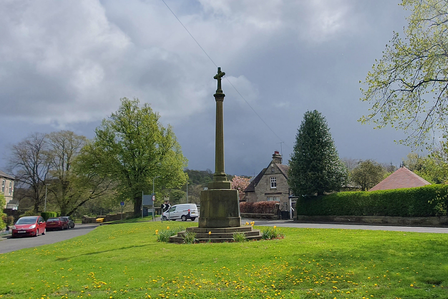
Return back to the village across the bridge. On the green at the southern end of the bridge stands the elegant village War Memorial (21a) commemorating those who gave their lives in Two World Wars. Then turn into the former North Wylam station yard (22) now laid out as a car park. In 1881 it was used for displaying sixteen ‘modern locomotives’ which took part in a procession from Newcastle to Wylam as part of the celebration to mark the centenary of Stephenson’s birth, and this event was perhaps the highlight in the story of the Scotswood-Newburn-Wylam railway.
Looking north across the car park are the stone houses of Falcon Terrace and to the left, the former village school, now occupied by the Library, Playgroup and a small Railway Museum (where displays illustrate Wylam’s unique contribution to early railway history and there are working scale model locomotives of Wylam Dilly and Puffing Billy). In the mid-nineteenth century Wylam Ironworks (23) occupied the site later used for the school. Few signs of the iron industry remain, although lumps of the waste clinker (‘scoria’) can be seen in the retaining walls to gardens on both sides of Main Road through the village.
The ironworks was established by Thompson Brothers in 1836. The brothers were the two sons of Benjamin Thompson, a director of the Newcastle and Carlisle Railway Company who also had an interest in various industrial enterprises in the North East. He lived at Wylam Hall for several years while his sons managed the ironworks. The firm built steam locomotives at Wylam and produced six engines (each costing over £1,500) for the Newcastle and
Carlisle Railway Company between 1838 and 1841.
Thompsons left in 1844 and although Bell Brothers took over the works, the discovery of iron ore in the Cleveland Hills in the late 1840’s and the subsequent development of ironworks around Middlesbrough (Bells themselves established an ironworks at Port Clarence on the Tees in 1853) meant the death of small and comparatively isolated ironworks like Wylam, and the local works closed in 1864.
The single blast furnace at the works stood on the line of the road, immediately outside the school playground, and behind this were rows of beehive coke ovens set into the bank. Several of the disused ovens remained until the school was built in 1909-10.
From the old north station yard car park, follow the track of the former waggonway/railway eastwards for some 250 metres and on the left among the outbuildings of Bythorne Farm is the site of the former North Wylam Colliery (24). This pit, the last to work in the village, was once known as the ‘Ann Pit’ and later as the ‘James Pit’. it closed in 1933.
Some two centuries ago the Hedley locomotives began work and ‘Puffing Billy’ and ‘Wylam Dilly’ might have been seen belching smoke and fumes whilst pulling wagons along this route between the colliery and the river staithes at Lemington. There are now two, small, working scale-models of these locomotives exhibited in Wylam Railway Museum.

About 200 metres past the farm and standing by the track is George Stephenson’s Birthplace (25). Known historically as High Streethouse, from its position alongside what had at one time been the old post road between Wylam and Newburn, this small stone house, with its red pantiled roof, is where Stephenson was born on 9th June 1781. At that time, there were four families living in the house, each occupying a single room, and the Stephensons, who had six children, lived in one of the ground floor rooms. The family left Wylam in 1789, when George was only eight years old, some twenty three years before the famous locomotive experiments were carried out in the village by Hedley and his colleagues. The cottage is now owned by the National Trust. As at mid 2024 it is closed for the time being except in conjunction with NT guided walks once a month and on heritage open days in early autumn – see the NT web site for details.
Immediately beyond the cottage, turn left through the gateway and follow the track leading behind the back of the building between the fields and then up the hill. The oak tree on the right was planted by the Lord Mayor of Newcastle in June 1881, to mark the Stephenson centenary, and new trees were planted alongside the waggonway in 1981, the bicentenary of his birth.
East from here, towards Heddon-on-the-Wall, lies Close House (26), a fine country mansion built in 1779. The Close House Estate was owned by the Bewicke family (no relation to Thomas Bewick, the famous local wood engraver) and at the time when the early locomotives were first brought into use, Calverley Bewicke, (over whose land a wayleave for the waggonway had previously been obtained when horses hauled the wagons) threatened a legal action to prevent the use of ‘monster’ locomotives, which he regarded as a serious and dangerous nuisance. Fortunately for the history of locomotive development, the dispute was satisfactorily resolved! Close House is not on the route of this walk, but can be glimpsed from it. Public rights of way in Heddon Parish go much closer.
Follow the track north up to The Rift (27) on the brow of the hill. Part of the range of stone farm buildings, some with their distinctive stone archways in traditional Northumbrian style, have been attractively renovated. Walk through the building on a double bend, pass the converted farm buildings and paddock turn left on to the signed footpath. Walk around the perimeter of the paddock and down through the wooded Rift Dene and back towards the village. Beyond the dene, the scrub covered mound on the left hides a few foundations of the winding engine of the old Hope Pit (28), known locally as the Chuckee Pit. This pit had been worked periodically during the 18th and 19thcenturies, but eventually closed in 1893-4. The embankment which carried the waggonway linking this pit to the station sidings ran down from here towards the river.
Continue across the field, through the gate and along the path bordering the housing estate. Beyond the houses, the path crosses an open landscaped area, Engine Dene (29).
It was from near here that brick earth was extracted during the Victorian era and brick makers were employed by the Blackett Estate to manufacture bricks and tiles for use in the village. The rate of payment was equivalent to 4p for every hundred bricks produced! One man could make about 1,000 per day.
When Septimus Forster, a Northumberland coal-owner, leased the Wylam Hills Colliery (30) during the 1870’s, he was given permission to construct a waggonway from the colliery (which lay to the northwest of the village, behind Wylam Hills Farm) down this dene to the station, but there is no record of this ever having been done. Although this colliery closed at the time of the First World War, coal was being extracted from nearby Horsley Wood during the 1920’s.
Cross the dene, past the end of Algernon Terrace and join Holeyn Hall Road opposite Wylam Hills, which was until the 1990’s an active dairy farm. The farmhouse remains a fine solid stone building, built about 1858 and typical of many Northumbrian farmhouses of that period. The rest of the site of the farm is now a housing development.
One of the village’s more unusual past industries, a Patent Lead Shot Manufactory (31) was located in what was the stock yard of the farm. It was presumably because of the Blackett family’s close associations with lead mining in Allendale and Weardale that the industry was introduced into the village. Under an agreement dated 18 November 1799, between Christopher Blackett, Joseph Locke, a Newcastle merchant and Richard Welton of Newcastle, a glass-blower, Welton was to be paid 23/(£1.15) per week for seven years for his services as a shot-maker in the manufacture of lead shot at Wylam. This document still survives in the Northumberland Archive at Woodhorn.
A unique feature of this industry was that, instead of building an expensive shot tower, use was made of a disused pit shaft for casting the shot – an ingenious and cheaper alternative. Little is known about the early history of the firm of Locke, Blackett & Co., which was founded in 1797 but the local directories show that they remained in Wylam until at least 1834, and were important lead merchants in Newcastle. The firm remained independent until 1936 and became part of the Associated Lead Manufacturers group in 1950. As late as 1877, a Newcastle merchant, Robert Lampen, had the lease of the ‘Shot Pit’ in Wylam, but there is no record of shot being produced after that date.
Turn right and walk south down Church Road (a continuation of Holeyn Hall Road) and you will reach the church again. That completes the walk. We hope you have enjoyed it.
Note on larger houses north of the village (not on the walk)
There are few houses of special architectural or historic interest in Wylam, but two, Holeyn Hall and Oakwood House, are sited in the north of the village to the east of Holeyn Hall Road, which links the village with the A69 Newcastle-Hexham-Carlisle trunk road.
John Dobson, the famous Newcastle architect, was involved in designing substantial extensions to Holeyn Hall (32) in 1858, only six years after it was built for Edward James, a wealthy Newcastle lead merchant, who had previously rented Wylam Hall from the Blacketts.
In 1894, Charles Parsons (who subsequently became internationally famous as the inventor of the steam turbine) purchased Holeyn Hall and carried out several of his engineering experiments in the adjoining workshops and parkland. During the First World War he made Holeyn Hall available as a Convalescent Hospital for the treatment of wounded soldiers. He owned the Hall until his death in 1931, but spent much of his time in later years at his estate at Ray, near Kirkwhelpington.
Oakwood House (33) lies to the south of Holeyn Hall and is well screened by trees. A Georgian building, it was the home of various members of the Blackett family during the 19th century, although they also owned (and occasionally occupied) both Wylam Hall and Wylam Cottage (34). Houses (32), (33) and (34) are all in private grounds, though may be glimpsed from public highways or rights of way